
In order to save time with the 36000 communes game, I created a small programm that lists all the french municipalities from my CSV note file. furthermore, this program now keeps me up to date with all geographic games in France and traces a nice map of my hunt for euros. Now this program is available to all:
ebt.fr.eu.org
There is a similar program available for Luxemburg :
ebt.lu.eu.org
So here will be the place to share your findings about it, send your wishes and report bugs. I'll try to keep this page updated with known problems so the happy few users are informed.
problèmes connus
- In France the map has municipalities from 2018 while the list is sorted with the latest data (2019) this means that 241 new municipalities from 2019 are not covering their exact area on the map.
Map of municipalities (France and Luxembourg)
Map of municipalities (France and Luxembourg)
Last edited by aloxe on Wed Feb 05, 2020 9:33 pm, edited 1 time in total.
a̳l̳o̳x̳e̳ • my other stats • my map of France
-
Henk Draijer

- Euro-Master

- Posts: 16948
- Joined: Mon Apr 18, 2005 9:41 pm
- Location: Zandvoort (NL)
- Contact:
Re: Map of municipalities (France and Luxembourg)
Nice picture aloxe. 
- image.png (81.84 KiB) Viewed 5179 times
Geduld is een schone zaak.
This is me.
My ebtcheck / My nigmm 0.071 / My EBTST)
The international HH:MM:SS list, with a daily update. (If you like it, join in)
This is me.
My ebtcheck / My nigmm 0.071 / My EBTST)
The international HH:MM:SS list, with a daily update. (If you like it, join in)
Re: Map of municipalities (France and Luxembourg)
Now you can also make a map for Luxembourg.
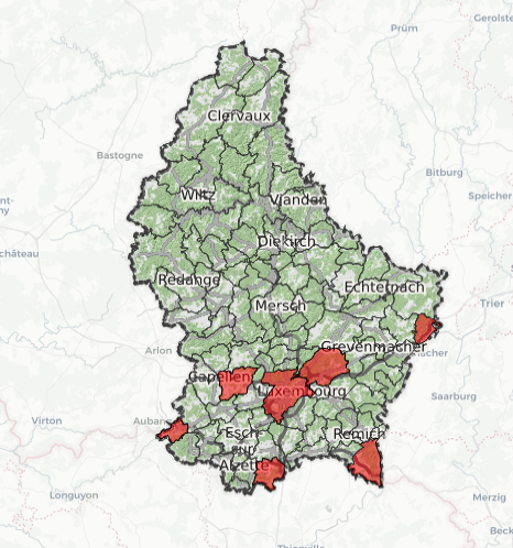
enjoy!
enjoy!
a̳l̳o̳x̳e̳ • my other stats • my map of France
-
lmviterbo

- Euro-Master
- Posts: 6532
- Joined: Thu Aug 21, 2003 5:23 pm
- Location: Lisboa, Portugal
- Contact:
Re: Map of municipalities (France and Luxembourg)
These are really nice and easy to use!
Thanks to this tool, I was able to correct my few registers in France.
I hope you are thinking of doing the same for other countries. Like Portugal, for example.

Thanks to this tool, I was able to correct my few registers in France.
I hope you are thinking of doing the same for other countries. Like Portugal, for example.
-
Henk Draijer
- Euro-Master
- Posts: 16948
- Joined: Mon Apr 18, 2005 9:41 pm
- Location: Zandvoort (NL)
- Contact:
Re: Map of municipalities (France and Luxembourg)
And The Netherlands, please.
Geduld is een schone zaak.
This is me.
My ebtcheck / My nigmm 0.071 / My EBTST)
The international HH:MM:SS list, with a daily update. (If you like it, join in)
This is me.
My ebtcheck / My nigmm 0.071 / My EBTST)
The international HH:MM:SS list, with a daily update. (If you like it, join in)
Re: Map of municipalities (France and Luxembourg)
I wish I could easily do that but for now, I'd like improve what is done already and make it solid enough to handle more countries. This is why I am requesting public feedback… and maybe more users from these EBT-low-activity countries
I also have to admit that I have less motivation to add countries where my score would be lower… ¯\_(ツ)_/¯
a̳l̳o̳x̳e̳ • my other stats • my map of France
-
lmviterbo
- Euro-Master
- Posts: 6532
- Joined: Thu Aug 21, 2003 5:23 pm
- Location: Lisboa, Portugal
- Contact:
Re: Map of municipalities (France and Luxembourg)
I don't know what data you need. In Portugal, A. Simões (with a little help from me) has codified all municipalities and districts (and also all cidades and vilas, which are kind of top level and 2nd level populated places).
Re: Map of municipalities (France and Luxembourg)
As an example, for France. I am using:
Chargement de la base des codes postaux. Source : INSEE/La Poste sur unpkg.com
This is the most important one, a merge of municipalities with their unique code with the postcode official database. While EBT uses the postcode to fight homonymes, the postcode can't be a reference because it is often used by many municipalities. So I need a unique (INSEE) number as a reference. There are updates every year (except on municipal election years) so I am lucky this one has been compiled and is up to date but I had to convert the format and can't automatically grab the latest.
Chargement des données des altitudes moyennes. Source : Opendatasoft (Licence Ouverte) (2013).
The only altitude database I found is 7 years old, this means there are possible 2000 municipalities with an approximate (wrong but not too much) height.
Chargement des données de superficie. Source : sql.sh (CC-by-sa) (2016).
Surface database is also older and source of aproximations
Chargement des données de population. Source : INSEE (données de 2017 publiées en 2019).
Luckily the population file is a public database that is updated every year
Carte des communes de France par région
The second most important is the geojson file with the limits of all french municipalities. This is a huge work and it is splited by regions and I load directly from the project: https://github.com/gregoiredavid/france-geojson/ My main problem is that this data is one year old so there are about 230 municipalities that are not correct. I would love to be able to update it, it is only about merging polygons but I don't have software for that. What is important is that the geogson data is using the same reference as my first database, the unique INSEE code. With this it is easy to mark the map with valid municipalities.
 For Luxembourg, I went on the Geoportail.lu and I had access to all needed data (often available after I requested it by email). I got a bit of help to build the map from the API managed by the public service of the Grand Duchy. I hope that every country will have their data available like this very soon.
 For Portugal I think this is good to have a list of concelhos with their postcode, a possible unique identification number and possibly another list with the freguesias and their concelhos. Then, there need to be a file with this same list and their borders in gpx, kml or geojson. When I look at wikipedia and OpenStreetMap, I don't feel that such file exists.
 For the Netherlands (as Henk asked) The dutch Wikipedia team is quite good and update the kaart van Nederland met gemeentegrenzen every year at minimum. I suspect there is a gpx map available somewhere but haven't looked yet. The list of municipalities is easy to get aswell but what would be needed for Eurobilltracker data is the list of dorpen with attached municipalities. I know I have notes recorded in Abcoude, in Mijdrecht but do I know I have notes in de Ronde Venen?
Again I would first like to review and improve this software and I'll then be happy to share the code with some of you who want to make the same for other countries.
Chargement de la base des codes postaux. Source : INSEE/La Poste sur unpkg.com
This is the most important one, a merge of municipalities with their unique code with the postcode official database. While EBT uses the postcode to fight homonymes, the postcode can't be a reference because it is often used by many municipalities. So I need a unique (INSEE) number as a reference. There are updates every year (except on municipal election years) so I am lucky this one has been compiled and is up to date but I had to convert the format and can't automatically grab the latest.
Chargement des données des altitudes moyennes. Source : Opendatasoft (Licence Ouverte) (2013).
The only altitude database I found is 7 years old, this means there are possible 2000 municipalities with an approximate (wrong but not too much) height.
Chargement des données de superficie. Source : sql.sh (CC-by-sa) (2016).
Surface database is also older and source of aproximations
Chargement des données de population. Source : INSEE (données de 2017 publiées en 2019).
Luckily the population file is a public database that is updated every year
Carte des communes de France par région
The second most important is the geojson file with the limits of all french municipalities. This is a huge work and it is splited by regions and I load directly from the project: https://github.com/gregoiredavid/france-geojson/ My main problem is that this data is one year old so there are about 230 municipalities that are not correct. I would love to be able to update it, it is only about merging polygons but I don't have software for that. What is important is that the geogson data is using the same reference as my first database, the unique INSEE code. With this it is easy to mark the map with valid municipalities.
Again I would first like to review and improve this software and I'll then be happy to share the code with some of you who want to make the same for other countries.
a̳l̳o̳x̳e̳ • my other stats • my map of France
-
lmviterbo
- Euro-Master
- Posts: 6532
- Joined: Thu Aug 21, 2003 5:23 pm
- Location: Lisboa, Portugal
- Contact:
Re: Map of municipalities (France and Luxembourg)
Here's the official link for all polygon and lines and metadata:aloxe wrote: ↑Mon Feb 10, 2020 11:01 pm
Carta Administrativa Oficial de Portugal - Versão 2018 (em vigor)
It's in Portuguese but I guess you'll understand it, even if you need to translate the webpage.
On that page, the cartography of Portugal is divided into 5 parts: Continental Portugal, 3 groups of islands in the Azores, and Madeira.
For each of those, the downloadable zips include several files. As a preview, here's the list of files for Continental Portugal (not including metadata):
Code: Select all
Área Administrativa (Polígonos)
-------------------------------
Cont_AAD_CAOP2018.cpg —      1 KB
Cont_AAD_CAOP2018.dbf —  4 882 KB
Cont_AAD_CAOP2018.prj —      1 KB
Cont_AAD_CAOP2018.qpj —      1 KB
Cont_AAD_CAOP2018.shp — 49 460 KB
Cont_AAD_CAOP2018.shx —     26 KB

Troços (Linhas)
---------------
Cont_Troco_CAOP2018.cpg —       5 B
Cont_Troco_CAOP2018.dbf —    6.0 MB
Cont_Troco_CAOP2018.prj —     412 B
Cont_Troco_CAOP2018.qpj —     666 B
Cont_Troco_CAOP2018.shp —   25.7 MB
Cont_Troco_CAOP2018.shx —     73 KB
Am I on the right path? Am I being of help or, on the contrary, just trying to meddle with something I don't have a clue about?
Re: Map of municipalities (France and Luxembourg)
yes you are but I'll reply in private because this deeps into technical stuff and might become off topic…
a̳l̳o̳x̳e̳ • my other stats • my map of France
Re: Map of municipalities (France and Luxembourg)
Hey
Now luxembourg page can help you join the Lëtzebuerg A-Z game. Enter your CSV and the tool counts for you.
Now luxembourg page can help you join the Lëtzebuerg A-Z game. Enter your CSV and the tool counts for you.
a̳l̳o̳x̳e̳ • my other stats • my map of France
Re: Map of municipalities (France and Luxembourg)
Ahead of the EBT Meeting Luxembourg 2020 I updated the Luxemburgish map tool with a few nice features:
- Adding used flag (so you can post it on the forum)
- 102 lëtzebuergesche Gemengen game
- Lëtzebuerg A-Z game (with the list of visited lettres)
- Various map tiles (To help you prepare your next trip)
a̳l̳o̳x̳e̳ • my other stats • my map of France
Re: Map of municipalities (France and Luxembourg)
Small update on the way I list French municipalities.
It nows list all départements even the ones without any encoding. It also tells how many municipalities were visited per département.
It nows list all départements even the ones without any encoding. It also tells how many municipalities were visited per département.
- alpes.png (25.44 KiB) Viewed 4552 times
a̳l̳o̳x̳e̳ • my other stats • my map of France
Re: Map of municipalities (France and Luxembourg)
yet another cool update (cool if you plan a trip to France)
You can now display a map of all municipalities in a specific département with your visited municipalities already marked. The map is more precise can show shops, banks and ATMs if you zoom enough. Let me show you an example.
To access these maps, you need to display your full French map after you sent your note list and click on any municipality. You'll get a popup with the name of the municipality and the number of the département. Just click on the number and it will display the detailed map.
Let's say you go to Britany and you already visited Morlaix (29), you can see the Municipality of Plouezoc'h is not far but is it worth it to go on the other size of the Dourduff river? Well if you zoom in, you see that there is a café du port where you can buy a drink with a and even a car park not far.
Enjoy the summer !
and even a car park not far.
Enjoy the summer !
You can now display a map of all municipalities in a specific département with your visited municipalities already marked. The map is more precise can show shops, banks and ATMs if you zoom enough. Let me show you an example.
To access these maps, you need to display your full French map after you sent your note list and click on any municipality. You'll get a popup with the name of the municipality and the number of the département. Just click on the number and it will display the detailed map.
- Screenshot 2020-08-06 at 16.30.29.png (299.56 KiB) Viewed 4431 times
Let's say you go to Britany and you already visited Morlaix (29), you can see the Municipality of Plouezoc'h is not far but is it worth it to go on the other size of the Dourduff river? Well if you zoom in, you see that there is a café du port where you can buy a drink with a
- Screenshot 2020-08-06 at 16.23.26.png (310.22 KiB) Viewed 4431 times
a̳l̳o̳x̳e̳ • my other stats • my map of France
-
Montgomery Burns

- Euro-Master
- Posts: 3025
- Joined: Tue Mar 08, 2011 2:49 pm
- Location: Lis., PRT
- Contact:
Re: Map of municipalities (France and Luxembourg)
Although I'm not likely to use it any time soon, I must commend you for your excellent work. What a great-looking tool!